5. Corridor delineation
Source:vignettes/vig_05-corridor-delineation.Rmd
vig_05-corridor-delineation.Rmd
library(rcrisp)
library(sf)

bucharest_osm <- get_osm_example_data()
bucharest_dem <- get_dem_example_data()
In this notebook we explore how to delineate an urban river corridor using river Dâmbovița in Bucharest, Romania. We will use OpenStreetMap (OSM) data, first from the Overpass API and then from a local file.
Corridor delineation depends on the availability of OpenStreetMap street and railway data around the river. Sparse OSM data, especially too few river crossings, may lead to failed delineation.
city_name <- "Bucharest"
river_name <- "Dâmbovița"
We start by demonstrating the use of the
delineate_city_river() convenience function, which runs the
full workflow from city and river name with default parameters.
Internally, it carries out the following steps:
Defines the area of interest and delineation parameters with
define_aoi();Fetches city boundary, street and rail network, as well as river centreline and surface data from the Overpass API as shown in
vignette("getting-osm-data");Pre-processes the street and rail network for delineation as shown in
vignette("network-preparation");Constructs the initial corridor based on the chosen method. With the default
corridor_init = "valley", the Cost Distance Accumulation algorithm is used to delineate the corridor based on the digital elevation model (DEM) of the area retrieved from the Earth Search API. Ifcorridor_initis set to a numeric value instead, the corridor is initialised by buffering the river centreline with a buffer of that distance (in metres).Delineates the corridor based on the pre-processed network and initial corridor. Optionally, the corridor is split into segments based on the network and the river space is delineated.
delineate_city_river() returns an object of class
delineation, which is a named list containing zero or more
of the delineation layers valley, corridor,
segments, and riverspace, plus the base OSM
layers and delineation parameters. For step-by-step control, each of the
above steps can also be run individually using
define_aoi(), get_osm(),
get_dem(), and delineate().
bucharest_dambovita <- delineate_city_river(
  city_name,
  river_name,
  segments = TRUE,
  riverspace = TRUE
)
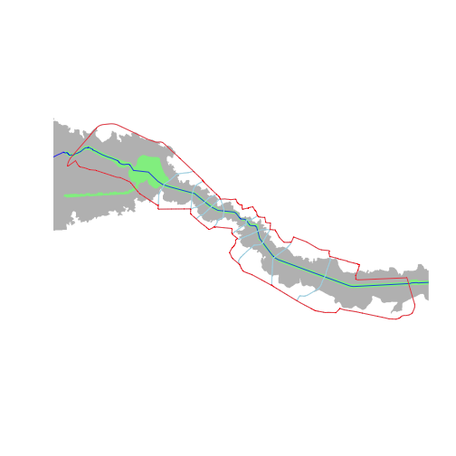
# Plot all layers within the extent of the delineated corridor
bbox <- st_bbox(bucharest_dambovita$corridor)
plot(bucharest_dambovita$valley, col = "grey", border = NA,
     xlim = c(bbox["xmin"], bbox["xmax"]), ylim = c(bbox["ymin"], bbox["ymax"]))
plot(bucharest_dambovita$riverspace, col = "lightgreen", border = NA,
     add = TRUE)
plot(bucharest_osm$river_centerline, col = "blue", add = TRUE)
plot(bucharest_dambovita$segments, border = "lightblue", add = TRUE)
plot(bucharest_dambovita$corridor, border = "red", wt = 2, add = TRUE)