2. Getting OSM data for delineation
Source:vignettes/vig_02-getting-osm-data.Rmd
vig_02-getting-osm-data.RmdIn this notebook we download OpenStreetMap (OSM) data needed for the delineation of the urban river corridor of River Dâmbovița in Bucharest, Romania. After attaching the packages used in the vignette, we specify the city name, the river name, and the CRS, and we make sure that we provide a buffer around the river used to retrieve OSM data.
library(rcrisp)
library(purrr)

city_name <- "Bucharest"
river_name <- "Dâmbovița"
network_buffer <- 3000  # in m, buffer around the river to get the network
buildings_buffer <- 100  # in m, buffer around the river to get the buildings
We start by getting the bounding box and projected CRS for the study area.
bb <- get_osm_bb(city_name)  # Get bounding box from OSM
crs <- get_utm_zone(bb)  # Get UTM zone for Bucharest
Using the obtained bounding box and corresponding CRS, we get the
different layers of OSM data needed for the delineation of the urban
river corridor. We will get the city boundary, the waterways, the street
network, and the rail network using built-in functions from the
rcrisp package.
city_boundary <- get_osm_city_boundary(bb, city_name, crs)
river_centerline <- get_osm_river_centerline(bb, river_name, crs)
river_surface <- get_osm_river_surface(bb, river_centerline, crs)
river <- c(river_centerline, river_surface)
aoi_network <- get_river_aoi(river, bb, buffer_distance = network_buffer)
streets <- get_osm_streets(bb, crs)
railways <- get_osm_railways(bb, crs)
aoi_buildings <- get_river_aoi(river, bb, buffer_distance = buildings_buffer)
buildings <- get_osm_buildings(bb, crs)

bucharest_osm <- list(
  boundary = city_boundary,
  river_centerline = river_centerline,
  river_surface = river_surface,
  aoi_network = aoi_network,
  streets = streets,
  railways = railways,
  aoi_buildings = aoi_buildings,
  buildings = buildings
)
The above layers can also be obtained with the all-in-one function
get_osm(). Optionally, a buffer around the river can be
specified for the retrieval of OSM data.
bucharest_osm <- get_osm(city_name, river_name,
                         network_buffer = network_buffer,
                         buildings_buffer = buildings_buffer)
The resulting object is a list with all the layers obtained above.
names(bucharest_osm)
#> [1] "bb"               "river_centerline" "aoi_network"      "streets"
#> [5] "railways"         "river_surface"    "aoi_buildings"    "buildings"
#> [9] "boundary"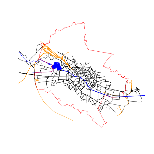
All layers combined (buildings not shown)
Individual layers can be written to disk before being read in for delineation.